Introduction and summary
In the 1920s, the U.S. Bureau of Reclamation proposed constructing an enormous dam on the Colorado River that would flood parts of the Grand Canyon and submerge Hualapai tribal lands. At 740 feet high, it would have been the tallest dam in the Western Hemisphere.1
The proposal, known as Bridge Canyon Dam, was part of a massive expansion of dam and reservoir infrastructure on the once free-flowing rivers of the Western United States in the early 20th century. At the time, nearly every major river was considered for this type development, leading to the construction of the Hoover Dam, the Glen Canyon Dam, and many of the 12,000 dams that now dot the rivers of the American West. Dams helped meet the needs of a growing nation, serving as a brick-and-mortar solution to irrigate arid agricultural land, supply drinking water, control floods, and generate power. By the 1950s and 1960s, dams were being constructed at a breakneck pace with little regard for impacts on the environment or outdoor recreation.2
At the same time, public sentiment on the purpose of rivers was beginning to shift. Dams’ devastating impacts on recreation and a river’s most basic ecological functions were becoming clearer as fish and wildlife populations crashed. Calls for protecting and restoring rivers began to carry the day. In 1968, after public opposition from the National Park Service and growing protests from the Sierra Club and local activists over the project’s impacts on one of the nation’s most famous natural landmarks, the Bridge Canyon Dam proposal was officially tabled.3
That same year, Congress passed the Wild and Scenic Rivers Act in an effort to restore balance to the nation’s rivers after years of massive federal dam projects and industrialization along the nation’s waterways. The preface to this landmark legislation4 offers a simple guiding principle for federal actions on the nation’s waterways: If federal and state agencies are going to dam and divert some sections of rivers, they must preserve and protect others.5
In the 50 years since the act was passed, there has certainly been much to celebrate—almost 12,000 river miles now enjoy protection under the act. Landmark environmental laws, such as the Clean Water Act, have led to the cleanup of many damaged rivers—including the Cuyahoga River in Ohio, which repeatedly caught on fire, most infamously in 1969.6 And the nation has developed a collective awareness about the connection between natural, free-flowing rivers and quality of life. Today, a proposal such as the Bridge Canyon Dam would be considered dead on arrival.
But the state of Western rivers today remains far from healthy, and there is still a need for better policies and management to balance environmental and economic needs. A new analysis from the Center for American Progress and Conservation Science Partners finds that nearly half—49 percent—of all river miles in the West have been modified from their natural state.7 More than one-fifth of the West’s river miles, including nearly all major rivers, no longer flow freely, as upstream dams impede water on its way to the ocean.8 And flood plains, areas along rivers that play an important role for wildlife habitat and the water quality, have been heavily affected by development: 42 percent have been altered.9
Development within rivers and flood plains impedes the environmental function of Western rivers, driving declines in species such as salmon, and creating increasingly evident vulnerabilities to drought across the West.10 Damage to rivers also results in economic costs that are often unaccounted for, such as catastrophic floods or dam breaches that put private property and infrastructure like drinking water, irrigation, and hydropower, at risk.
Communities, businesses, and government agencies across the West have started taking steps to address these problems. However, many tools to protect or restore Western rivers are underutilized, and investments in restoration and management improvements to protect agriculture, ecosystems, and city water supplies are too rarely adopted.
Smart policy can keep the state of Western rivers from declining further—meeting the needs of communities while improving the ecological and physical factors that make these rivers the lifeblood of the West. To meet this growing challenge, CAP recommends the following approaches to protect these critical waters:
- Protect what’s left of the large, natural rivers. Through the Wild and Scenic Rivers Act and other tools that protect both land and water, federal and state agencies should set an ambitious goal to guarantee permanent protection for half, or about 2,300 miles, of the remaining large, natural rivers in the West that run through unprotected lands.
- Conserve and restore headwaters. Policymakers should prioritize expanding watershed restoration efforts by federal land agencies; reforming mining laws to reclaim abandoned mines and reduce risks to rivers; and attracting investment from utilities and private firms to protect headwater resources through forest and river restoration.
- Rethink river infrastructure. When it comes to levees and dams, federal and state agencies must modernize necessary functions and restore natural processes where built infrastructure is no longer a net benefit.
- Collaborate to improve the health of entire watersheds. Invest in efficiency and conservation efforts to protect both rivers and the communities that depend on them. This includes working on demand for water with both landowners and cities and supporting private lands conservation efforts that improve river health.
Taking these steps at the federal, state, and local levels will build on growing efforts to scale up conservation and restoration projects that are emerging across the West. By securing the natural heritage of its rivers, the West can ensure a better future for its people.
The state of Western rivers
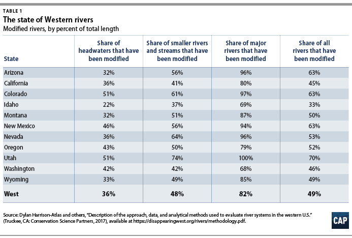
In February 2018, the Center for American Progress and Conservation Science Partners—a nonprofit scientific organization that specializes in cutting-edge data science and mapping—released the first comprehensive evaluation of the state of rivers in the West. The analysis considered a wide range of factors, including dams, diversions, and development on more than 280,000 miles of waterways—from tiny headwater streams to major rivers such as the Colorado and Columbia.
The results, some of which are laid out in Table 1, demonstrate the extent to which Western rivers have been altered—almost half, or 49 percent, of all river miles in the region are no longer natural—and form the basis for the recommendations in this report.
For more information and the results of the Disappearing Rivers analysis, visit DisappearingWest.org/Rivers.html.
Protect the last big, natural rivers
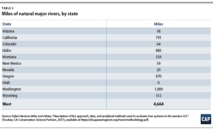
Not surprisingly, major rivers in the West—generally, those big enough to boat on—are the most affected by human development. Their importance to Western economies has led to significant degradation and development of these waterways. Large dams for water storage and power generation have blocked many rivers, and others have been altered by levees and diversions as communities and agriculture have concentrated along riverbanks. As a result, less than 18 percent of all major Western rivers can be considered natural today. The situation in some states is especially grim: in Utah, less than 1 percent of major river miles can be considered natural.11
But there is hope. CAP’s analysis found that where rivers in the West flow through protected lands—such as national parks, wildlife refuges, and wilderness areas—they are on average 50 percent more natural than the river miles that flow through unprotected areas. This shows that land conservation strategies can help maintain or improve the health of the few big, natural rivers that are left in the West.
If policymakers can protect the rivers themselves—or the adjacent land through which they flow—they can dramatically improve the outlook and health of rivers. With 80 percent of major rivers already altered from their natural state, it is critically important to protect the limited number of major rivers that still maintain their natural characteristics. CAP recommends that policymakers conserve half, or about 2,300 miles, of the remaining large, natural rivers through land or rivers protections.
There are a number of available state and federal policy tools to accomplish this. Land protection laws, such as the Wilderness Act of 1964 and the Antiquities Act of 1906, can protect the natural qualities of rivers on federal land by enacting stronger conservation guidelines for land managers. And the Wild and Scenic Rivers Act allows for federal protections tailored to the values of a specific river, including its natural qualities or the recreation value it provides.
Federal-level actions
The federal government has several tools at its disposal to protect the last big, natural rivers.
Identify National Wild and Scenic River System designation opportunities
Congress should use its authority under the Wild and Scenic Rivers Act to review existing recommendations for Wild and Scenic River designations by federal land management agencies and direct an independent assessment of potential protections for the remaining natural stretches of major rivers identified in CAP’s analysis, including river miles flowing through both public and private lands.
Protect big, natural rivers for wild, scenic, or recreational values
Working with local communities to identify opportunities, Congress and the Trump administration should use their authorities under the Wild and Scenic Rivers Act to protect the last wild, major rivers. They should place special emphasis on the recreation value or wild traits of large rivers outside existing protected areas, in order to conserve the economic and environmental contributions of these major waterways.
Use land protections to conserve natural rivers
Congress and the Trump administration should also use land protection authority, including the Wilderness Act or the Antiquities Act, to enhance protections for lands around key rivers on protected lands to secure their natural characteristics.
State- or local-level actions
States and communities can take their own steps to protect rivers for their natural characteristics.
Create state registries of wild rivers
State legislatures should establish river protection registries to protect important rivers and the values they provide to economies and the environment. In the West, California and Oregon currently have their own state river protection system and can be used as a model for other states.12
Protect lands where wild rivers still flow
State policymakers should prioritize protections, such as state parks, new recreation areas, and conservation easements, around vulnerable wild rivers.
Spotlight on success: The Wild and Scenic Rivers Act
In 1968, Congress passed the Wild and Scenic Rivers Act so that certain rivers “shall be preserved in free-flowing condition, and that they and their immediate environments shall be protected for the benefit and enjoyment of present and future generations.”13 Under the act, Congress has the flexibility to tailor protections for rivers as wild, scenic, or recreational, depending on the use and development of the river.
Many river designations lie within federally owned lands, but protections can also be granted on rivers as they flow through state and private land. Agencies typically work with states and counties to determine whether zoning regulations are sufficient to protect a designated river, and the act permits federal agencies to arrange a limited number of purchase agreements or development easements with landowners along each river mile for additional protection.14 States can also earn federal protection for rivers that are part of that state’s river protection system.15
The program has protected many well-known rivers, including portions of the Missouri River in Montana and the Salmon River in Idaho, yet these protections only represent 0.25 percent of the total river miles in the United States.16 It is clear that the Wild and Scenic Rivers Act is an underutilized tool, especially given the importance of rivers to the outdoor recreation economy. The Outdoor Industry Association estimated that water sports, such as boating and angling, generated $139 billion in direct economic activity—and 1.2 million jobs—in 2017.17 And across the West, watersheds with the highest density of rivers show 717 percent more outdoor recreation spending than watersheds with low river density.18 In this 50th anniversary year, groups such as American Rivers are advocating for expanded use of this important tool, including the designation as wild and scenic of an additional 5,000 river miles across the United States.19
Restore headwaters
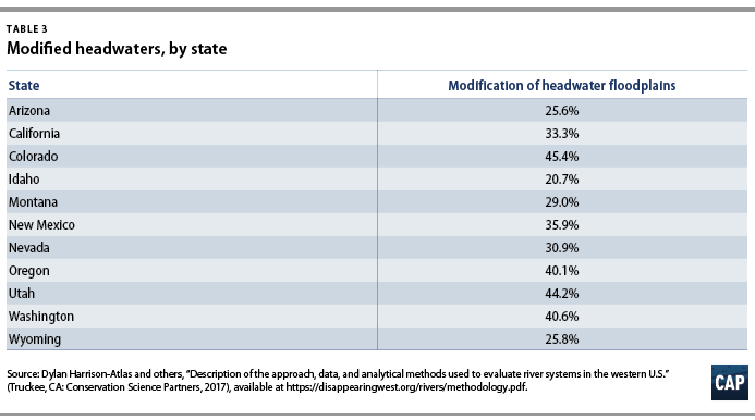
Almost half of all headwaters in the West have been altered by human activity. Mining, in particular, has been a major driver of development across Western states, and more than 169,000 miles of rivers in the West are downstream from at least one coal or hard rock mine.20 In the Colorado River basin alone, there are more than 20,000 active or abandoned mines that pose a constant threat to water quality.21 Disasters such as the 2015 Gold King Mine spill, which dumped millions of gallons of toxic effluent into the Animas River in Colorado, served as a wake-up call that our tools to assign financial responsibility for active mines and raise funding for cleanup of abandoned mine sites remain very limited.22
Roads pose another significant challenge for river health. Throughout the West, road construction has historically depended on the installation of culverts, metal tubes that allow water passage under road crossings. But culverts interrupt the shape of natural river courses and restrict flow patterns, disrupting habitat for important fish species such as cutthroat trout.
Finally, climate change and some forest management techniques have altered forests across the West from their historical ecological state. This has resulted in uncharacteristically intense wildfires and degraded the function of streams and rivers by increasing soil erosion and changing the hydrological patterns in forests.23 Research by the U.S. Forest Service finds that 118 million acres of Western watersheds are impaired, which negatively affects the clean drinking water they provide.24
Protecting rivers and small streams near their source has a positive impact on every community that lives downstream, especially those who rely on rivers and streams for drinking water.25 Therefore, policies that target restoration and encourage smart investments in headwaters and small rivers can have an outsized impact on the health of Western watersheds. But agencies first need greater resources to make headway on watershed restoration. The following are several opportunities to make these investments.
Federal-level actions
Congress should use smart policy to safeguard headwaters and direct funding toward restoration of rivers, streams, and the landscapes through which they flow.
Reform federal mineral policy
Federal mining policy is antiquated, with limited avenues to fund cleanup or restoration of abandoned mines. Congress should pass one of the proposed bills that implement a fee or royalty program to generate a fair return for the public from its mineral resources and direct these funds to treat mining sites that threaten the West’s rivers and streams.
Increase funding for culvert removals on federal land
Congress should use the 2018 farm bill as an opportunity to increase funding for culvert removal and road renovations through the Forest Service’s Legacy Roads and Trails program.
Prioritize impaired watersheds with restoration funding
In March 2018, Congress adopted a bipartisan solution to fix wildfire funding and rightfully consider the worst wildfires to be natural disasters that are eligible for federal relief. This procedural change will free up hundreds of millions of dollars for the Forest Service to invest in forest restoration, and the agency should direct these funds to the watersheds that its own scientists have identified as ecologically damaged.26 Previous CAP research suggests that this would have significant economic and environmental benefits, protecting drinking water for millions of people and creating up to 40,000 jobs.27
State- or local-level actions
The connection between the health of headwaters and drinking water infrastructure downstream is increasingly clear. States and cities should work to secure the health of this natural infrastructure, drawing on the experiences of a growing number of forward-thinking communities.
Evaluate source watersheds as a part of drinking water infrastructure
Cities already face significant costs to maintain existing water treatment and delivery systems; drinking water utilities in the West are estimated to face more than $400 billion in infrastructure maintenance in the coming decades.28 In light of these cost commitments, the fiscal prudence of counting the benefits and risks of upstream water sources is clear. Studies on the contributions of natural infrastructure to water quality and quantity are becoming more common in the West,29 as are examples of how these benefits can be linked to existing investment plans used by utilities.30
Dedicate funding to protect drinking water sources
Where it is cost-effective, cities and utilities should direct consistent funding to projects that protect forests, headwaters, and other natural infrastructure. There are numerous examples of cities and water utilities determining that investments in natural infrastructure represent cost savings over expanding built infrastructure or responding to crises. States should engage utilities, landowners, and land management agencies to ensure that policies support investments in the health of headwaters.31 Western cities and towns now have a range of examples—such as Denver; Ashland, Oregon; and Flagstaff, Arizona—that demonstrate how to raise funds and establish partnerships to protect these resources.32
Create markets to drive investment in headwater restoration
Policymakers should expand eligibility for wetland mitigation credits to include projects that remove culverts and road barriers on headwater rivers and streams. Having a system to quantify the value of removing these obstacles will help direct investment to the most important restoration projects. Oregon is currently piloting a project, called the Fish Passage Mitigation Bank, to test evaluation tools and market mechanisms; it may serve as a model for other states.33
Spotlight on success: Restoring forest streams
Western communities and decision-makers have been paying greater attention to forests and headwaters for the services they provide—notably as an important supply of clean drinking water. Approximately 180 million Americans across the nation get their drinking water from sources in national forests.34 This new focus has been paying dividends for downstream communities, and there is room to expand on this success.
It is increasingly common for utilities to partner with the Forest Service and other landowners to fund forest restoration to protect water supplies.35 For example, after studies showed Santa Fe, New Mexico, could incur up to $280 million in damages to their reservoirs and outdoor recreation industry from a catastrophic wildfire, the local water district began investing roughly $250,000 annually in forest restoration projects to reduce fire risk.36 Several utilities along Colorado’s Front Range, including Denver Water, have partnered with the Forest Service to make similar investments against the risks that catastrophic fires pose to their reservoirs.37 In 2012, the citizens of Flagstaff, Arizona, voted to approve a $10 million city bond to finance forest restoration—including prescribed burning and carefully planned tree thinning—in the Coconino National Forest, which supplies 50 percent of the city’s drinking water.
States have also moved to make it easier for cities to pursue similar programs. In 2016, the California Legislature passed AB 2480 to help utilities mitigate stressors to the state’s water supply after years of drought.38 The law recognizes the value of forests and watersheds to drinking water infrastructure, which enables utilities to use the same financing approaches used for built infrastructure to pay for watershed restoration. Conserving landscapes, such as wet meadows in the Sierra Nevada and Cascades mountain ranges, can support California’s water supply more cost-effectively than new construction, saving ratepayers money.
These partnerships with utilities are important for the Forest Service, since they help amplify federal funding streams for restoration. As these partnerships have developed, the Forest Service has refocused on its original charter—to secure water supplies39—by incorporating the value of watersheds into its planning processes and creating data sets that guide investments in their restoration. One such program, called Forests to Faucets, connects land cover data with maps of drinking water withdrawals to measure the relative importance of different watersheds to the public. This helps partners, such as drinking water utilities, decide where restoration of forests or mountain meadows might be good investments to protect drinking water.
The Forest Service has also undertaken restoration of degraded waterways through the Legacy Roads and Trails program. Thus far, the program has funded culvert removals that have reconnected more than 1,500 miles of streams in the past 10 years. But thousands of miles of river remain fragmented.40 Restoring more of these small streams, many of which are spawning locations for salmon, trout, and other important species, would have significant environmental and economic benefits.
Rethink river infrastructure
Dams and levees, built to provide irrigation, generate electricity, and regulate river flows, have significantly altered most Western rivers. Across the West, there are more than 12,000 major dams and tens of thousands of smaller dams.41 While many of these structures provide meaningful social and economic value, a large number of others are obsolete, costly, and unsafe. These dams have significant impacts on the function of rivers. They block fish movement and migration and change water temperatures and flow patterns that are necessary for ecosystem health.42
Whether a dam is necessary or can be removed, there are tested solutions that can dramatically improve the health of Western rivers. For large and important dams, structures that allow for fish passage, such as interconnected pools called fish ladders, which gradually swim over dams, have been used to help connect habitats on either side of dams. Releasing water from a dam to mimic historical river and flood patterns can improve flow and restore sediment movements downstream that are necessary to maintain fish habitat. These types of reforms cannot fully restore rivers, but they can reduce the effect of dams on flow and wildlife, as well as better balance competing needs. For dams that no longer serve their purpose, policymakers and dam owners should consider dam removal and explore creative funding mechanisms to reconnect rivers.
Federal-level actions
As river infrastructure ages, federal agencies need to reconsider their role in the future of dams.
Include dam removal as an option in environmental assessments
As dams age, there need to be ways to have honest, fact-based conversations about the efficacy of maintenance or removal. Considering dam removal as an alternative during environmental assessments under the National Environmental Policy Act, and as part of Federal Emergency Management Administration (FEMA) reviews when these structures are damaged during disasters, are two approaches to evaluate costs and benefits and to make the best decision possible about the future of individual dams.43
Draw private investment into dam removal projects
The U.S. government should identify ways to encourage private investments to remove dams that have been identified as obsolete or dangerous. One option is through wetland mitigation requirements under Section 404 of the Clean Water Act.44 Run by the Army Corps of Engineers and the Environmental Protection Agency (EPA), mitigation banking is estimated to generate more than $2.9 billion in funding for restoration to compensate for development’s impacts on wetlands and streams.45 Restoration for streams and rivers alone is already estimated to generate $230 million to 442 million annually.46 Mitigation has occasionally been used as a funding source for dam removal, but rules should more clearly define it as an acceptable form of compensation for wetland impacts. Previous clarifications, including the 2008 mitigation banking rule that better defined restoration requirements, have led to large increases in private investment in restoration.
State- or local-level actions
States play an important role in the development of river infrastructure to protect rivers, ecosystems, and communities.
Plan for the future of aging dams
Although many major dams are owned and operated by the federal government, the vast majority of dams are owned by private entities, and monitoring them is the responsibility of individual states.47 As policymakers in Western states plan for future water needs and maintenance commitments, they should weigh the value of existing dams and probable upkeep costs against the benefits of river restoration. As with culverts, states should incentivize dam removal and river restoration by allowing removal to serve as compensatory mitigation for other infrastructure upgrades.48
Spotlight on success: Dam removal
As the 21st century progresses, the upkeep costs of dams will need greater attention. Many dams are more than 50 years old—which is often considered the designated lifespan of a dam—and are in desperate need of maintenance or removal.49 The American Society of Civil Engineers gave a collective D rating to the 2 million dams in the United States. The crisis at California’s Oroville Dam in February 2017, which prompted the evacuation of more than 180,000 residents living downstream, underscored the danger of deferred action to address dams.50
Considering these growing costs and risks associated with aging dam infrastructure, dam removal should be more seriously explored. Nearly 1,400 dams have been removed in the United States since 1912, including 72 in 2016 alone.51 Some of these projects have been major operations, funded and implemented through government agencies. For example, two dams on the Elwha River in Washington’s Olympic Peninsula were removed between 2011 and 2014.52 Built in the early 20th century, the dams prevented runs of several salmon species from spawning in Olympic National Park, affecting the local ecosystem as well as the livelihoods of tribes in the area. After decades of planning, the river is now free-flowing, and scientists are monitoring the recovery of fish and other species in the river’s delta after 100 years of erosion and degradation.53 Salmon are also returning to streams beyond the dam sites—the 2016 spawning run was the highest in 30 years—which is helping restore the region’s ecology and its cultural heritage.54
Other dam removal projects that focus mainly on smaller structures and provide an evidence base for the benefits of removing small dams that provide limited value.55 For example, the Hewlett Foundation’s Open Rivers Fund is supporting the removal of a 6-foot-tall irrigation weir on Oregon’s Wagner Creek, a tributary to the Rogue River. An in-river irrigation intake will be installed as well, so that small farms’ water needs continue to be met while leaving the channel open for threatened steelhead and salmon to reach spawning habitat.56
Consider the multiple benefits of flood plains in infrastructure decisions
States work with counties, communities, and FEMA to prepare for flood events. As these groups evaluate vulnerabilities and plan infrastructure, they should consult the growing evidence that healthy flood plains can protect property by absorbing floodwaters. They should also acknowledge environmental benefits—such as habitat for threatened species and recharge for groundwater—as additional values that flood plains provide. Land use policy should encourage communities to consider these multiple benefits when planning for development near rivers or prioritizing investments in potential flood-control infrastructure.
Spotlight on success: Rethinking levees and flood plains
Levees are embankments built to prevent the overflow of a river, and they now define the flood plains for many rivers. Some areas in the West, such as California’s Central Valley, boast complex levee systems that have significantly altered river ecosystems to protect farmland and communities from winter floods.
Research has shown that with smart planning, these flood control structures can help restore river ecosystems that have been affected by development. One example is the Yolo Bypass, a system of levees and weirs that route floodwaters around the Sacramento metropolitan area. During winter storms and other flood events, the bypass can hold four times the amount of water as the main channel of the Sacramento River and protect the city from being inundated.57 During the rest of the year, the floor of the bypass is used for agriculture.
Recent projects have used the bypass to mimic the valley’s historic flood plains and balance the needs of fish and agriculture. Results have shown that this utilization of the bypass can significantly benefit young salmon as they migrate downstream.58 Allowing some water to slowly move through the wetlands and rice fields during the winter—instead of opening the bypass only for major flood events—provides sheltering habitat where young salmon can safely grow at faster rates than they do in the main channel of the river, leaving them in better shape for their journey to the ocean.59
Other states could adopt California’s approach by applying a multibenefit perspective in their flood protection plans.60 Policies that acknowledge the benefits of natural infrastructure as a flood control tool will help ensure that upgrades and management can be done in a way that capitalizes on the value of more natural flood plains.
Collaborate to improve the health of entire watersheds
In many ways, there is no more complex management challenge than a river, which flows through myriad political boundaries and ecosystems; experiences demands from countless user groups; and faces existential threats from climate change and innumerable other human activities.
As such, any effective river policy must be comprehensive and approach management at a basin scale. This includes balancing demand from cities and agriculture with the environmental needs of rivers and the systems they support. And it includes encouraging investment in the 140,000 miles—roughly 50 percent—of rivers in the West that run through private properties.61
There are two approaches to balancing Western communities’ water needs and the health of river systems: conservation of river flows, and restoration and protection of river channels and flood plains. Finding solutions that engage private actors and balance different interests across the watershed should be a priority for states and for federal agencies.
Federal-level actions
The federal government should use its convening power and existing conservation programs to direct more resources to improving watershed health.
Fund watershed improvements through the Natural Resource Conservation Service
The Watershed Protection and Flood Prevention Act created a Natural Resource Conservation Service (NRCS) program to provide technical and financial assistance for watershed restoration projects on private lands—such as irrigation upgrades in Oregon to conserve water—but funding is inconsistent. 62 Congress should guarantee funding in the 2018 farm bill for this program.
Use USDA conservation programs to support watershed-level solutions
The 2014 farm bill created new conservation approaches at the U.S. Department of Agriculture (USDA) that emphasize partnerships and common geographies, such as regions and watersheds, and innovative solutions to shared problems. The Regional Conservation Partnership Program (RCPP), an NRCS effort, could better encourage watershed-level programs by making it easier for downstream water users, such as utilities or companies, to work with landowners upstream.63 Support for innovative approaches through programs like the Conservation Innovation Grants, could be expanded to help more complex river conservation efforts such as water quality trading or water markets become established.
Create watershed working groups to coordinate management across the federal government
Partnerships among agencies and states in the Colorado River basin to pursue the twin goals of protecting communities and the river provide a good example of the benefits of coordination at the watershed level across the West. Cross-agency working groups that include the USDA, the U.S. Department of the Interior, the EPA, the Army Corps of Engineers, and other relevant federal agencies would help ensure that agency actions are better directed at resolving the environmental, social, and economic challenges present in each watershed. Some watersheds, such as the Yakima River basin and the Colorado River basin, already have cross-agency working groups, which can provide a model for expanding coordination.
State- or local-level actions
State and city policy plays a key role in water use and should be adapted to give water users tools to invest in conservation.
Support flow guarantees through short-term leasing or markets
The uncertainty of precipitation in the West creates challenges for the state agencies, water utilities, and landowners that need to allocate and use water resources. This is problematic for both business and ecosystems. Western states do recognize ecosystem health as a beneficial use of water resources, and they should make it easier for different user groups to support watershed health through trading mechanisms such as water markets or clearinghouses for short-term leases.64 Recent efforts, such as the Colorado River basinwide Pilot System Conservation Program and seasonal leases between the Colorado Water Trust and the Upper Yampa Water Conservancy District, have shown that this approach provides flexibility to meet both environmental and agriculture needs in a watershed and protect water rights holders.65
Use water plans to proactively prepare for scarcity
Adaptation to future water availability should be based on thoughtful planning rather than a reaction to crises. As the climate changes, states should use water plans to examine longer-term vulnerabilities and prepare cities and water districts to proactively invest in conservation activities that will protect the public from future droughts and build capacity to balance urban, agricultural, and environmental needs.
Pursue conservation and demand reduction to prevent shortages
Cities and irrigation districts should account for water usage types and audit delivery systems to find efficiency opportunities, following the best practices outlined by the EPA.66
Spotlight on success: Reducing demand during drought
Maintaining river flow, and protecting it during times of drought, is complex. Conservation measures are becoming more effective, but can and should be expanded, especially in areas where droughts are commonplace.
In San Diego, water allocations from the Colorado River were central to the city’s growth. By 1991, this water, delivered by the Metropolitan Water District of Southern California (MWD), comprised 95 percent of the city’s supply. That year, low rainfall meant that the MWD needed to cut the supply to San Diego by 20 percent, which exposed the flaws in its municipal water planning. The city invested heavily in alternative sources, including agreements with irrigation districts and using conservation in homes and businesses to reduce demand. As of 2012, only 45 percent of the city’s water was being purchased from the MWD.67
Outside of urban areas, the major challenge for demand reduction is the heavy reliance on irrigation across the West. Irrigation accounts for almost 75 percent of all water use in the West.68 There are signs, however, that conservation can be achieved in this sector as well. Between 2012 and 2015, California experienced an intense period of drought, but agricultural production still grew as landowners shifted to less water-intensive crops that created higher value.69
Pilot programs focusing on basin-scale conservation have shown promise for organizing scarce water resources across both urban and agricultural landscapes. In 2014, the Bureau of Reclamation launched the System Conservation Pilot Program in the Colorado River basin to maintain sufficient water levels in Lake Powell and Lake Mead through voluntary conservation efforts. Since its inception, the program has saved more than 115,000 acre-feet70 of water that can be stored in the reservoirs.71 Because raising water levels in the two reservoirs create shared benefits—when levels drop below a certain elevation, water deliveries decline for everyone—the effort is viewed as a win-win for all. Landowners who volunteer to implement conservation practices are compensated, and their contributions are temporary, so there is no concern that their participation forfeits permanent water rights. While long-term declines in precipitation across the Colorado River basin remain concerning, the lessons from this program provide some insight into how communities can adapt to protect rivers and the people who depend on them.
Spotlight on success: Building partnerships for river restoration
There is a growing list of success stories where policy can engage landowners and investors in successful river, channel, and flood plain restoration projects.
The Sage Grouse Initiative, a landmark program within the NRCS to help protect and restore habitat for the greater sage-grouse, has focused much of its efforts on protecting and restoring rivers on ranches across the sagebrush expanses of the intermountain West. These riverine habitats are key to survival for the sage-grouse and 350 other species but are also critically important for ranchers who need good water supplies for their livestock.
In the upper reaches of the Colorado River basin, ranchers have partnered with the NRCS and nongovernmental organizations (NGOs) such as American Rivers and Trout Unlimited to restore river function by building riffles and other in-channel barriers that slowed flow and added oxygen to the river.72 The improved habitat spurred trout recovery, and the slower flows raised the water table, which benefited ranchers along 10 miles of the Colorado River.
Both the Sage Grouse Initiative generally and the Colorado River restoration project specifically are due, in part, to the RCPP. The RCPP targets specific ecosystems and watersheds, funding landowners who develop projects in partnership with NGOs, businesses, and government agencies. This regional focus is promising but can be better leveraged to encourage conservation when the direct benefits to a property owner are lower or less obvious.
Conclusion
With half of its river miles damaged by development, the West is at a crossroads. Policymakers can maintain the status quo and continue to lose the function of rivers, or they can tap into new ways of thinking to restore and protect rivers as the foundation of Western communities.
Only by charting a new path can policymakers secure a more stable and prosperous future for the region. But these new policies will require investments in the United States’ public lands; smart restoration of rivers and the infrastructure that shapes them; additional protections for natural rivers; and a commitment to working with landowners and cities to pursue shared goals that improve water security and the health of river systems.
In the 50 years since Congress passed the Wild and Scenic Rivers Act, policymakers have made great progress in restoring the nation’s rivers. But the threats facing western rivers are different today than they were when the law was first passed. Hopefully, future generations will look back at how the nation responded to this new time of crisis for rivers and remember that society again took a forward-looking stance to benefit the health of communities, the survival of ecosystems, and the future of the West.
About the author
Ryan Richards is a senior policy analyst for Public Lands at the Center for American Progress, where he focuses on natural resource economics and markets. His past work has covered a variety of topics, including water policy, ecosystem restoration, and private lands conservation.
Acknowledgements
The author would like to thank Mary Ellen Kustin, Kate Kelly, Matt Lee-Ashley, Emily Haynes, and Nicole Gentile for their assistance in the preparation of this report.